

Best of Sicily static Map

After the main entrance, at the first junction we find on the left the observation shed overlooking the [1] old salt pans now abandoned that host different species of birds both migratory and sedentary. If equipped with binoculars it is possible to observe different species of birds including pink flamingos.
Back at the junction continue along the path that arrives at the main intersection: in front of you the access to the beach of Vendicari where you can swim with a view of the Tonnara, on the right the path 2, on the left the path of the Tonnara.
Continuing along the path that leads us to the suggestive ruins of the [2]Tonnara, we have on our left the Pantano Grande, a freshwater basin very important for the coexistence and refreshment of many species, which make the ecosystem rich and lively.
After the Tonnara we meet the [3]Swabian Watchtower and the [4] Hellenistic tanks , cavities dug directly into the rocks for different uses, including that of fish preparation and "garum" fish-based seasoning.
We can only vaguely imagine the appearance of the place in the Greco-Roman age. We can certainly understand the reasons why this place has never ceased to be enormously fascinating for man.
Continuing our walk we skirt on one side still the rich and wide Big Quagmire up to Pantano Piccolo and on the other the rocky coast of the sea that accompanies us throughout this stretch, giving us a vast and rich panorama where we can be lucky enough to look at birds or other animals in their habitat.
We arrive at the famous [5] Calamosche Beach , characteristic for being a sandy basin closed by the rocky coast. Mixing, the coast and sand, the coast is enriched with marine species that we can admire by diving. A perfect place for snorkeling.
We continue our walk to the nudist beach of [6] Marianelli going up the rocky shore opposite to the one from which we descended to reach the Calamosche Beach.
Reached the Marianelli beach, continuing our itinerary you have to overcome the lower mouth of the river Tellaro to reach the beach [7]Eloro-Tellaro , where the presence of fresh water increases the environmental value of the place. Here it will be possible to see parts of the walls and architecture of the ancient Greek city of Eloros, currently closed to visitors.
On the promontory there are the remains of the ancient Syracusan colony [8]Heloros , to reach it you have to leave the reserve and follow the dirt path always keeping to the right.
Beyond the promontory is the beach of [9]Eloro-Pizzuta , to reach it you have to leave the reserve and follow the dirt path always keeping to the right.
Finally the [10] Pizzuta Column , a monument dating back to the Greek period can be reached from the main road.

The first information about the existence of the salt pans of Vendicari date back to the fifteenth century, probably the area of the marsh was used even in Greek times, since nearby there are remains of tanks for the processing of salted fish.
The salt pans were an important resource for the area, they fed the salt market that was transported by sailing boats "varchi 'i sali".
The work of the salt pans was typically seasonal from March to August. A typical day of the salt workers began in the morning at dawn and continued until 11:00, thus avoiding the scorching midday heat. He resumed work in the early afternoon until around 5:00 p.m.
The salt pans were closed in 1951 following a flood that had caused much damage to the area. Today the salt pans are used by birds as an oasis of refreshment and are one of the most important attractions of the reserve.
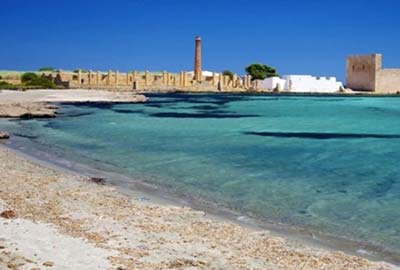
A wonder to visit dating back to the eighteenth century, is the Tonnara di Vendicari: also called Bafutu.
The construction of the Tonnara dates back to the eighteenth century, the activity developed thanks to the presence of the nearby salt pans that allowed the extraction of salt; The tuna was caught in the waters in front and transported to the balata where it was cut and processed, then in the actual plant the tuna was cooked in the ovens and canned.
The activity of the plant has had alternating phases, flourishing periods to periods of closure based on the cost of the product and the competition of the nearby traps of Marzamemi, Avola, Noto and Syracuse.
In 1943, following the landing of the Allies, but also due to a poor economic yield of the tuna trade, the plant was closed.
Today it remains a testimony of the ancient Sicilian tradition of tuna traps.
In 1970 Vendicari risked becoming an industrial area, fortunately the monstrous project failed.

Dating back to medieval times, the Swabian Tower was most likely built by Peter of Aragon, Count of Alburquerque and Duke of Noto (1406-1438) to signal and repel the attacks of Saracen and Barbareschi pirates.
The date of foundation of this tower remains uncertain. The oldest source that mentions the existence of the building is by Tommaso Fazello, a Sicilian historian, who indicated the construction of the tower precisely at the behest of Pietro D'Aragona.
The construction of this tower was necessary to guard and defend the loaders the warehouses where foodstuffs were stored for trade; the area that corresponds to the current Vendicari reserve, in fact, has presumably been a port center for rural communities since late antiquity. This ancient commercial function has been prolonged over time, as evidenced by a document of 1396, which grants the city of noto the commercial activity through the Vendicari airport.
The military activity of the Swabian Tower, despite the collapses and alterations that have occurred since the sixteenth century and the devastating earthquake of 1693 that seriously damaged it, officially continued until 1867, when the Italian government counted it among the military buildings to be abandoned due to ceased functionality.
Compared to the original structure, the tower today appears almost halved in height due to the lack of the top floor (present only in the north wall), the vaults of roofs and the terrace.
On the north-east side there is one of the entrances, a rectangular door with a massive monolithic architrave. In this prospectus we can see on the floor one of the original windows of the structure.
On the tops of the south and west corners, there are corbels dating back to the sixteenth century, which served as a support to large balconies that housed lookouts, cannons and garrisons in countershoe.
In the north-east façade, at a height of 5 meters, we can see an arched door with a slightly lowered sixth, visibly "recessed" with respect to the façade. This was the entrance to the drawbridge.

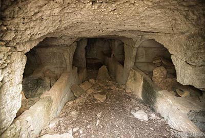
After passing the Swabian tower you reach the storage tanks of an ancient hellenistic establishment used for the processing of tuna and the production of garum; next to the tanks was also discovered a small necropolis.
Garum is a liquid sauce of fish entrails and salted fish that the ancient Greeks added as a condiment to many first and second courses.
Garum derived from the Greek name garos or garon (γάρον), which was the name of the fish whose intestines were originally used in the production of condiments. It is thought that the Garum was similar to the anchovy paste or the liquid of the brine of salted anchovies, which on the Amalfi coast and in particular in Cetara can be enjoyed even today with the name of "colatura".
In the Geoponiche, of unknown author and era, we read: "The so-called 'liquamen' is produced as follows: pour into a container the entrails of the fish and then salt; pour small fish, especially dairy, or small red mullet, or menole, or anchovies, or whatever small fish there is, all to be salted equally, to be left to mature in the sun and turn constantly.
After they have seasoned in the heat, the garum is drawn from them; a large basket is inserted into the full cavity of the above small fish: the garum will flow into the basket; what is poured through it, called "liquamen", will be collected.
Some also add two sextarians of old wine for each fish sextary. If you need to use the garum immediately, do not keep it so much in the sun, but boil it, doing so:
take the brine so concentrated that an egg can float there (if it sinks there is not enough salt), place the fish in it in another pot, add oregano and put it on the fire until boiling, that is, until it has reduced enough volume. Once cooled, place in a sieve a second and a third time, until it is clear. After putting the lid on, put it back on.
The flower of the garum, however, called aimàtion (from the Greek αἰμάτιον, "blood, blood"), is obtained as follows: take the entrails of the tuna together with the gills, the serum and the blood, on top spread salt and macerate for two months. The container is then perforated, the garum called aimation will come out of it".
Probably the most famous of the beaches of Vendicari is Calamosche, a ravine of extreme beauty destination of many of the tourists who visit this part of Sicily, a masterpiece of mother nature.
For those wishing to reach the beach of Calamosche directly, the paid parking is 1.2 km away on foot. Click on the P to get the navigation directions. Parking 3,5-5 €/day; 9-19 ; 7/7. Admission 3,5 €.
🚍 Bus Noto-Lido di Noto. Bus Stop Hotel Helios, then hiking of 4 km you reach the beach of Pizzuta, Eloro, Marianelli and Calamosche.
Natural beach in the name of freedom is Marianelli, a splendid ravine destination for naturists who love nudism and gayfriendly beach.
The sand is always golden and the sea has an impeccable clarity.
Arriving by car, the car park is about 750 meters from the beach.
🚍 Bus Noto-Lido di Noto. Bus Stop Hotel Helios, then hiking 2.5 km on the sand you reach the beach of Pizzuta then Eloro and then Marianelli.
Attention: due to what has just been described, this particular destination lends itself to a narrow target of users and much less to families.
Continuing south on the paths above the dunes you reach the beautiful Calamosche at about 800 meters.
South of the archaeological park (Heloros) Eloro is the second of the 4 beautiful natural beaches that are located north of Vendicari, with soft golden sand is bordered by dunes and Mediterranean vegetation.
Crossing the river Tellaro, at the south end of the beach, beyond the promontory you arrive at the beach of Marianelli.
There are no structures inside, only nature.
By car you can park at about 300 meters. Admission 3.5€.
🚍 Bus Noto-Lido di Noto. Bus Stop Hotel Helios, then hiking 1.5 km you reach the beach of Pizzuta and then the beach Eloro.
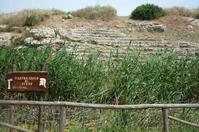
It is a coastal city - along the Via Elorina - founded at the end of the seventh century BC.C., important because it represented the extension of the power of Syracuse to the south.
The city was always faithful to the motherland until the fall into Roman hands which however allowed its continuity and productivity until the dismantling and destruction in Arab times.
Further traces of the exploitation of the place are the presence of some latomie (stone quarries) of the fifth century BC.C used in the ancient Greek city, for the construction of temples and monuments, which later became catacombs in the early Christian era.
The city walls, dated to the sixth century BC.C. in their original phase, were later rebuilt over the remains of the oldest ones, perhaps in the second half of the fourth century BC.C.
The most important sanctuary was located outside the walls: it was dedicated to Demeter and Kore and perhaps takes up an older indigenous Sicilian cult. It was located outside the walls and consisted of several rooms.
The portico was also connected with the agora, of which only the cisterns dug into the rock to collect rainwater remain visible. From the square a street headed towards the sea to the south-east: together with another street in a north-south direction it defined the axes of the urban structure of the city.
A sanctuary perhaps dedicated to the god Asclepius, of the fourth century BC.C., consisted of a courtyard surrounded by arcades, where the sick stopped and slept waiting for the visit in a dream of the god, which would lead to healing.
Nearby there was a small thesauròs, that is a building in the shape of a small temple in antis, intended to house the votive offerings and dated to the second half of the fourth century.
To the south, on the slopes of the hill, there is a Greek theater, partly carved into the rock and partly built, dating back to the late fourth - early third century BC.C., partly affected by a reclamation canal built in the thirties.
To the north-west was the Pizzuta Column, a funerary monument, consisting of a colossal column in limestone rocchi (diameter of 3.80 m and height reconstructable in about 10 m). Nearby there is an hypogeum carved into the rock, datable to the second half of the third century BC.C., already seen in the excavations of Orsi in 1899 and subsequently reburied.
The last of the beautiful natural beaches of the Vendicari reserve on path 1, this beach was a place of parties and games of virility of the ancient inhabitants. The sea is clear blue and crystal clear, there are no equipped facilities, the beaches are connected by paths. This delightful place is ideal for nature lovers looking for peace and tranquility close to the sea, very popular on weekends in July and August.
NOTE: to reach the Eloro beach coming from the Tellaro beach you must leave the reserve and return later following the dirt road.
The parking area is free and is about 200 meters from the entrance of the beach.
🚍 Bus Noto-Lido di Noto. Bus Stop Hotel Helios, then hiking 1 km you reach the beach of Pizzuta.
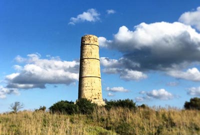
The column can be reached from the main road
☞ (click here for directions)
is a short stop for a short path that takes us to the Pizzuta Column, a path to an isolated archaeological find in this pre-reserve agricultural area.
It is a column probably dating back to the third century BC.C. which apparently seemed to be part of a celebratory monument. Only in the inspections carried out by Paolo Orsi it emerged that in reality it is a commemorative funeral monument, under which a stuccoed hypogeum compartment was found and adorned with two warriors, one of whom was regent a shield adorned with stylistic features dating back to the time of Hieron II. From this the alleged dating was deduced.
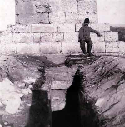
The term Pizzuta is probably due to its emergence isolated from the surrounding environment, or probably to the precious type of almond that populates that area, called "pizzuta".
Damaged by the terrible earthquake of 1693, it was qualified as a valuable find and restored in 1793 at the behest of Ferdinand I of the Two Sicilies, as reported by a marble plaque set in it.
Note: Those coming from Tellaro beach must go outside the reserve to reach the column.
ITINERARY
1
From the main entrance we take the main path on the right until we reach the sea, from here we head right again in the direction of the Citadel.
The first point of interest is the [11]Pantano Roveto, where we find observation huts along the way, panoramic points to have the opportunity to admire life within this fascinating ecosystem, a perfect place for birdwatching.
Continuing our path we have on one side then the cliff and on the other the Pantano rich in vegetation typical of the place.
Along the coastal stretch you can see the Island of Vendicari, very close to the coast, also part of the Oasis.
Continuing we pass a small mouth of the Pantano that pours into the sea and we enter towards our right to reach the [12]Trigona, with the Pantano behind it. We admire the Byzantine structure that together with the others have determined an important documentation of the medieval period in these areas.
We continue on our path to find ourselves on the area of the Necropolis.
Continuing the itinerary to the south we meet on the left the path that leads to [13] the beach of the citadel , a splendid natural location (possible presence of algae) where you can enjoy a crystal clear sea, having the sensitivity to respect the place and any areas forbidden to the nesting of turtles.
Continuing we reach the [14]Citadel: an area of Byzantine settlement of which only a recent former Palmento remains, born for the production of wine but now used to host naturalistic and cultural events in the area.

The largest of the marshes, the Bush quagmire has an extension of 1.24 km² and the mouth that connects it to the sea is usually buried. The average depth is 30-40 cm, while the maximum is 1-2 m.
The huts arranged around the quagmire allow you to observe the local fauna without being seen.

La Trigona: cuba (church) Byzantine square plan with three apses, an upper dome and an opening to the east so that, as tradition, the light of the full moon entered the building starting the holy Easter.
Cuba is among the most valuable finds that in chronological order testify to the continuity of housing of these places always affected by the presence of man for the richness of the fauna and the strategic position.
Not far from the Trigona are visible several Byzantine catacombs , in a good layer of conservation with family and single tombs. In the area was found, in the 70s of the last century, a tombstone with Jewish symbols. The area also has several remains of houses, a sign that the area was densely populated perhaps because of the nearby port, of which traces remain.
The arrival of the continuous threats by the barbarians first and then by the Arabs determined the abandonment of these places in favor of the inaccessible highlands of Pantalica, where the Byzantines moved.
Probably one of the most beautiful beaches of eastern Sicily, the beach is wide and comfortable, the sea has an exceptional clarity. Possible presence of algae .
For those wishing to reach directly the beach of the citadel, the paid parking is 500 meters away. Click on the P to get the navigation directions. Parking 3,5-5 €/day; 9-19 ; 7/7. Entrance reserve 3,5 €.

The Cittadella dei Maccari is located at the extreme southern tip of the Vendicari nature reserve. The archaeological site of Cittadella, so called precisely because here stood a small town in Byzantine times.
The building on the promontory is the former Palmento for the production of wine, recently restored which now hosts naturalistic and cultural exhibitions in the area.
ITINERARY
2

the presence of the vast marshes has contributed to the creation of an ecosystem that is a reference point both for the birds that stop here in large numbers before reaching the migratory destinations throughout Europe, and for the ever-growing population of sedentary birds that has found a satisfactory habitat in Vendicari.
In fact, the area of the reserve is located at a latitude lower than the African coast by about 50 km
Sighting equipment
Recommended camera lens 400x ; you can use a 200x but it takes luck to make some decent shots; unfortunately the marshes are quite extensive and because of the visitors the birds prefer to stay as far as possible from the noises.
20x50 binoculars (also the 30€ one sold by the Chinese) gives the opportunity to admire the splendid specimens that live or pass through the reserve

The Courier of Leschenault (Photo: Dr. Ajay Balachandran) nests in Turkey, Syria, Jordan, Armenia, Azerbaijan and southern Afghanistan; winters on the coasts of the Persian Gulf, the Red Sea, the Gulf of Aden and the southeastern Mediterranean Sea; of pace in central-southern Europe including Italy, Scandinavia, united kingdom and North Africa.

The Piro Piro di Terek, of medium-small size, has a long beak turned upwards of orange color with the black tip and the webbed feet; the legs are long and bright orange. The upper feathers are gray, the lower ones are white.

The Narrow Tailed Snipe it lives in Asia, from Russia to Indonesia and from Iran to Malaysia, including Japan, Oman, Sri Lanka, Philippines, Maldives, Cocos Islands and Andaman and Nicobar Islands.It is passing through the Arabian Peninsula, Somalia, Kenya, Comoros, Seychelles, Christmas Island, Papua New Guinea and Australia.Rarely it also goes to Tunisia and southern Italy.

The Fawn Piro Piro (Photo: Stefano Benucci) lives in the Americas, the Caribbean and Russia.It is in step in western and northern Europe, in the Mediterranean Basin (including Italy), in Australia and on some islands of western Oceania, in Japan, Taiwan, in southern Africa, in Kenya and along the Gulf of Guinea.

Lesser crested terns(Thalasseus bengalensis) (Photo: oiseaux.net) is visible in Europe, Asia, and Africa; in Italy it breeds on the Pò's delta, in environments where there is water nearby.

Rüppell's warbler(Photo: G.Minuta) also known as Silvia with a black throat, is a migratory bird that nests in Greece, some large islands of the Aegean, in Turkey, Syria and in winter in the center and east of the Sahel (especially in Chad and Sudan).

The Chiurlottello (Photo: Migratoria.it) very rare bird lives in Eastern and Central-Eastern Europe, especially in Russia (Omsk region) where it nests, and Romania where it was last sighted. It winters in Italy, in the Balkan states and North Africa, in Turkey and in the states of the former Soviet Union.
Most common sightings
 |
Gray heron (Photo: Ómar-Runólfsson) |
 |
Dabchick |
 |
Great crested grebe (Photo: Marek-Szczepanek) |
 |
Redshank (Photo: Andreas-Trepte) |
 |
Ferruginous duck (Photo: Erbanor) |
 |
Egret (Photo: Andreas-Trepte) |
 |
Pink flamingos (Photo: Estormiz) |
 |
Avocet (Photo: Erbanor) |
 |
Azavola (Photo: Steve-Garvie) |

Why visit it: Fascinating Oasis in the south of Sicily that embraces an area of the Syracuse coast with clear beaches and clear waters. An area full of riches on all fronts, from biodiversity to geological history to archeology that reveals its ancient settlements.
Not to be missed: The beaches, the Tonnara and birdwatching.
The nature reserve "Oasi Faunistica di Vendicari" was established in 1984 by the Sicilian Region. Located precisely between Noto and Marzamemi, it is one of the most amazing ecosystems in the world.
Crystal clear sea, long and golden beaches, incredible landscapes, Mediterranean vegetation, bird watching observers that will allow you to admire flamingos, herons, storks and other splendid birds.
Both the terrestrial environments surrounding the marshes and the aquatic ones are characterized by an extraordinary variety of habitats and exceptional biodiversity.
This is due, as far as the first is concerned, to the presence of very different substrates, to particular hydrogeological characteristics and to the different physico-chemical characteristics of the waters.
So terrestrial environments enumerate valuable phyto-sociological associations, typical of these systems and of a great variety of species, some of which have almost disappeared in the rest of Sicily.
Info & Tickets
Visit 08:00/19:00 7/7
US € Full ticket 3,50 euro per person
Reduced ticket (for law enforcement agencies, environmental associations, students and scouts) 1.50 euros
Free for children under 8 years, disabled with accompanying person with prior authorization of the manager, subjects engaged in study, research and teaching activities and for institutional initiatives.
There is a family ticket costing Euro 7.00 for all members of the family.
The ticket applies and is valid for all 5 entrances of the protected area from Cittadella dei Maccari, Torre vendicari, Marianelli, Calamosche and Eloro.
Path 1 on foot: 12 km c.ca round trip
Path 2 on foot: 8 km c.ca round trip
Essential equipment: hiking or sneakers, water, mosquito repellent, hat and swimsuit in summer.
Important warnings: steep slopes, prohibition of fishing, hunting, introduction or removal of animal or plant species; absence of network signal in some areas.
The editorial staff assumes no responsibility in case of unforeseen events, changes, closures or deviations not reported.
Presence of reported nudism zones.
Absence of refreshment points within the reserve. Bring food and water with you.

Its peculiarity is given by the different biotypes that compose it: from the pools that form the marshes to the rocky and sandy coast or to the typical Mediterranean scrub.
There is a very dense Mediterranean scrub, which in general characterizes the territory with Lentisks, Myrtles, Wild Olive Trees etc.
The sandy coastal environment includes, distributed in strips parallel to the coast from the shore to the hinterland, Sea rocket, Salicornia, Beach-grass, Eryngium creticum, Maritime Euphorbia, Sea lily; Beach in bloom, Cornflower beach, Maritime fennel, in the stripes behind the dunes;
an exclusive, dense and uninterrupted strip of Mediterranean scrub with Juniper, together with Ephedra, Lentisk and Fillirea in the innermost and undisturbed dunes.
This great variety of environments is the essential basis for the varied presence of ecological niches, unimaginable elsewhere, which offer shelter to a large number of animal species, many of which are endangered in Sicily.

Vendicari represents not only an important neuralgic area in the migratory and wintering routes of many species of birdlife (over 200 species, some residents and some nesting, including the spatula, the gray heron, the stork, the flamingo, the shiny ibis, the wild goose, the pink gull, the black-winged stilt house, the stone chiurlo, others)
but it also gives shelter to many mammals (Sicilian shrew, dormouse, hedgehog, pygmy shrew, vole, porcupine, fox, weasel, wild rabbit), amphibians and reptiles (snake, grass snake, leopard rat snake, green lizard, marsh turtle) and insects.
Also important is the marsh environment , where there are numerous species of aquatic fauna (fishes, shellfishes, reptiles, amphibians and insects) and submerged vegetation (algae and different phanerogams, proper to these environments).
The marine environment in front of these marshes - characterized by low seabed constituted both by rock covered by algal associations and by sandy environments and grasslands of Poseidonia oceanica, and populated by appreciated fish fauna (sea-bass, sea bream, dassie) - is among the areas indentified by law for the institution of a marine reserve (AMP).

For nature lovers Vendicari offers the best beaches in all of Eastern Sicily.
All beaches have dedicated parking areas, distant from 200mt to 1.2 Km, all accesses are paid
The conditions of the beaches change from year to year, you can find algae , reeds or logs , being a reserve everything is part of an ecosystem and are not removed.
☞ From recent photos posted on Instagram or Google you can tell if and where there are algae or reeds.
The sea of Vendicari is extremely transparent, the best conditions are when there is little wind or the wind blows from the West, North West, South West.
From North to South the beaches of Vendicari :
Eloro Pizzuta beach
Adjacent to the ruins of ancient Eloro.
Eloro Tellaro beach
Beach bordering the mouth of the river Tellaro.
Marianelli beach
Nudist and gay friendly beach
Calamosche beach
Beach guarded in a wonderful cove.
Tonnara Beach
Beach close to the tonnara and the marshes
Vendicari Beach
Very long beach, sometimes forbidden due to the presence of turtle eggs.
Citadel Beach
Beach with a beautiful backdrop.